After a year of being cooped up inside from the COVID-19 pandemic, I’m dedicating this summer entirely to riding rail trails to an excessive extent. And since I read that the Ghost Town Trail was well-known for its industrial ruins and artifacts of Pennsylvania’s coal mining heritage, I couldn’t think of any better trail to start with.
The GTT follows the former Ebensburg & Black Lick Railroad between the towns of … well, Ebensburg and Black Lick. The trail was established in 1991 and is still growing. A northern loop from Vintondale to Nanty Glo by way of Elk Creek is nearly finished and will add a solid 14 miles of trails. If you want to skip the spur and stick to the mainline GTT, it’s roughly 33 miles from Ebensburg War Memorial Park to Saylor Park in Black Lick.

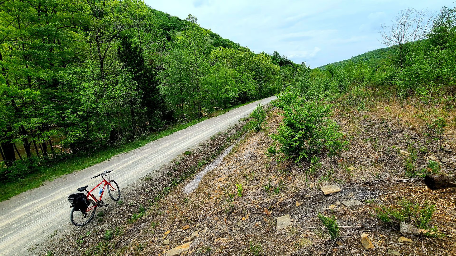
I started my ride heading west from Ebensburg, giving myself a nice downhill ride the entire way. Most guides recommend heading east from Black Lick, and I’d agree with them — Ebensburg is a much more enjoyable town in which to finish. But there were thunderstorms in the forecast and I wanted the added boost that the westbound downhill ride would give me.
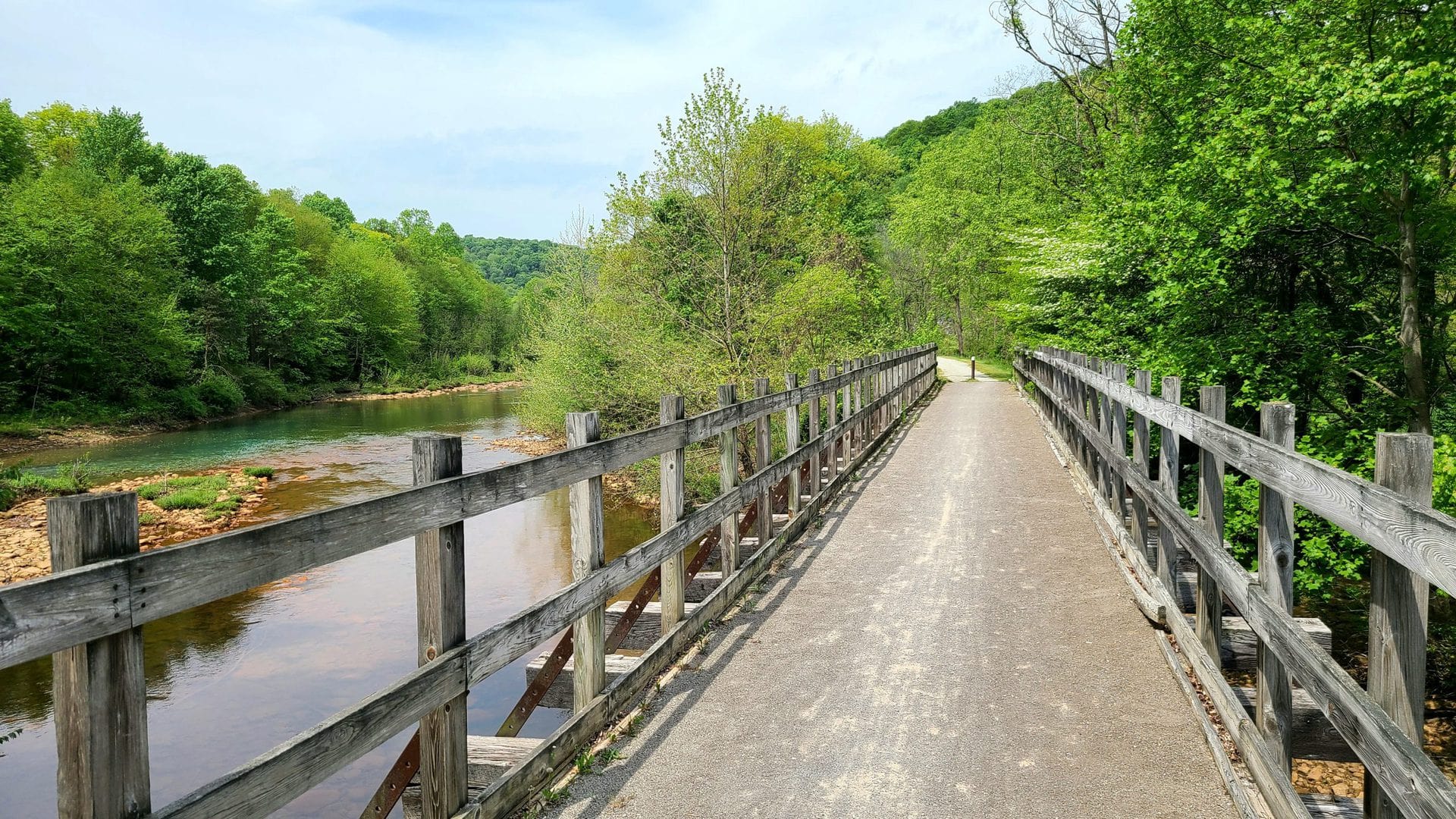
Blacklick Creek was my mostly-silent companion throughout most of the journey. It wanders back and forth across the trail like a golden retriever that swore it just saw something really amazing over here you guys I swear! It makes it easy to find the trail if you somehow manage to get lost (as I briefly did) and sets the stage for great photo ops.

The trail isn’t just natural beauty, though. Heading west, the first town I encountered after leaving Ebensburg was Nanty Glo. I have no idea where I picked this up but I always thought Nanty Glo was a bustling suburb of Pittsburgh.
As I entered the town, I came across the remains of a long-forgotten rail bridge. The bridge abutment had no markers or engravings of any kind. A trail led up the side but didn’t reveal anything useful. After getting home and digging into some area maps, it turns out that this was part of the Cambria & Indiana Railroad, formerly known as the Blacklick & Yellow Creek Railroad.
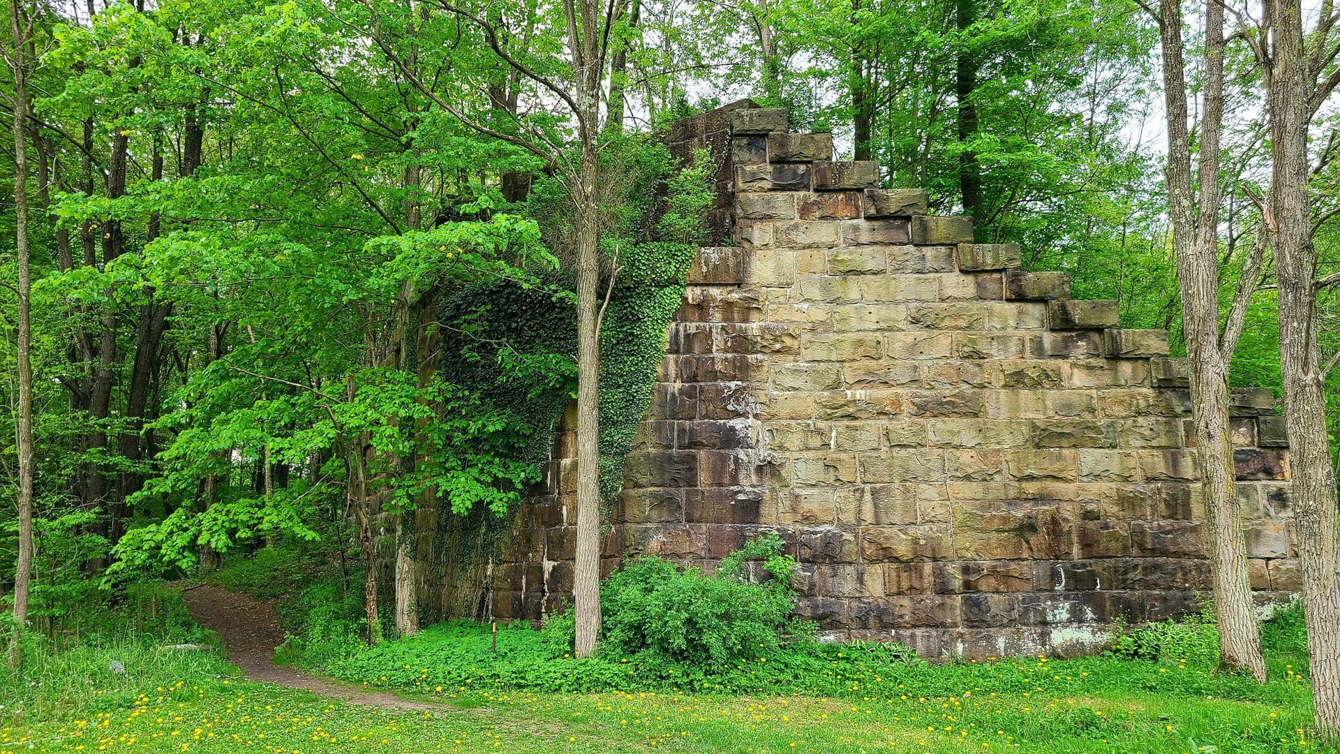
Originally founded in 1904, the history of the railroad gets a little fuzzy starting around the time of the 1977 Johnstown Flood. According to old mine maps, the main slope for the Monroe No 31 mine is just south of here. Today it’s buried under a passive AMD (acid mine drainage) treatment pond but around 1916 the Nanty Glo branch of the C&I was run to service the mine. Huge shoutout to this page for helping me put it all together.
I didn’t spend much time in Nanty Glo. I was only a fourth of the way through my journey and I wanted to build up as much lead time on the impending thunderstorms as possible. Nanty Glo is the last town of any size you’ll hit going west, so this is a good chance to double check your supplies.

About two miles west of Nanty Glo you’ll pass the Twin Rocks trailhead. If you absolutely have to cut this ride short, making Twin Rocks your eastern terminus will still allow you to see 70% of what the trail has to offer. Heading west from here I passed through SGL 79. Wear orange.
In case you needed a reminder that you’re in the bitumonous coal region, the trail will give you plenty of reminders. For one thing, you’ll find multiple outcroppings along the trail:

Another reminder is the waste pile as you approach Vintondale. If you grew up in anthracite country, you’ll call this a culm bank. If you grew up literally anywhere else, it’s a boney pile or waste pile. Either way it’s basically a pile of trash. It’s tiny fragments of coal mixed with iron, manganese, and aluminum. It’s too contaminated to use as fuel, but it does a great job at poisoning the creek. Note the orange rocks along the bank:

Just around the corner is the start of a passive AMD treatment facility. To make a long and frankly ingenious story very short, this is basically a series of manmade ponds that help reduce oxygen, separate solids, neutralize acid, and reintroduce oxygen to clean up the water. The ponds weren’t exactly flowing when I was there but the source of the runoff is the Vinton No 3 mine just east of the ponds.

If you ride the trail westbound, you’ll see what looks like a disused Jeep trail heading off to your left just before the first pond. I didn’t realize until I followed the GTT a little further ahead that this is actually part of the nearby park. Feel free to follow that trail! If you don’t, you’ll miss out on the litmus garden — an all natural status indicator of how the ponds are performing. Whichever way you go, each pond has a sign explaining what role it plays in treating the acid runoff.
Did I mention that it does all of this without any electricity or machinery?

Just past the AMD mitigation ponds is the town of Vintondle. As you approach, you’re greeted with a memorial to the coal miners who lost their lives in the nearby Vinton No 6 mine. It’s located where the original mine portal stood.
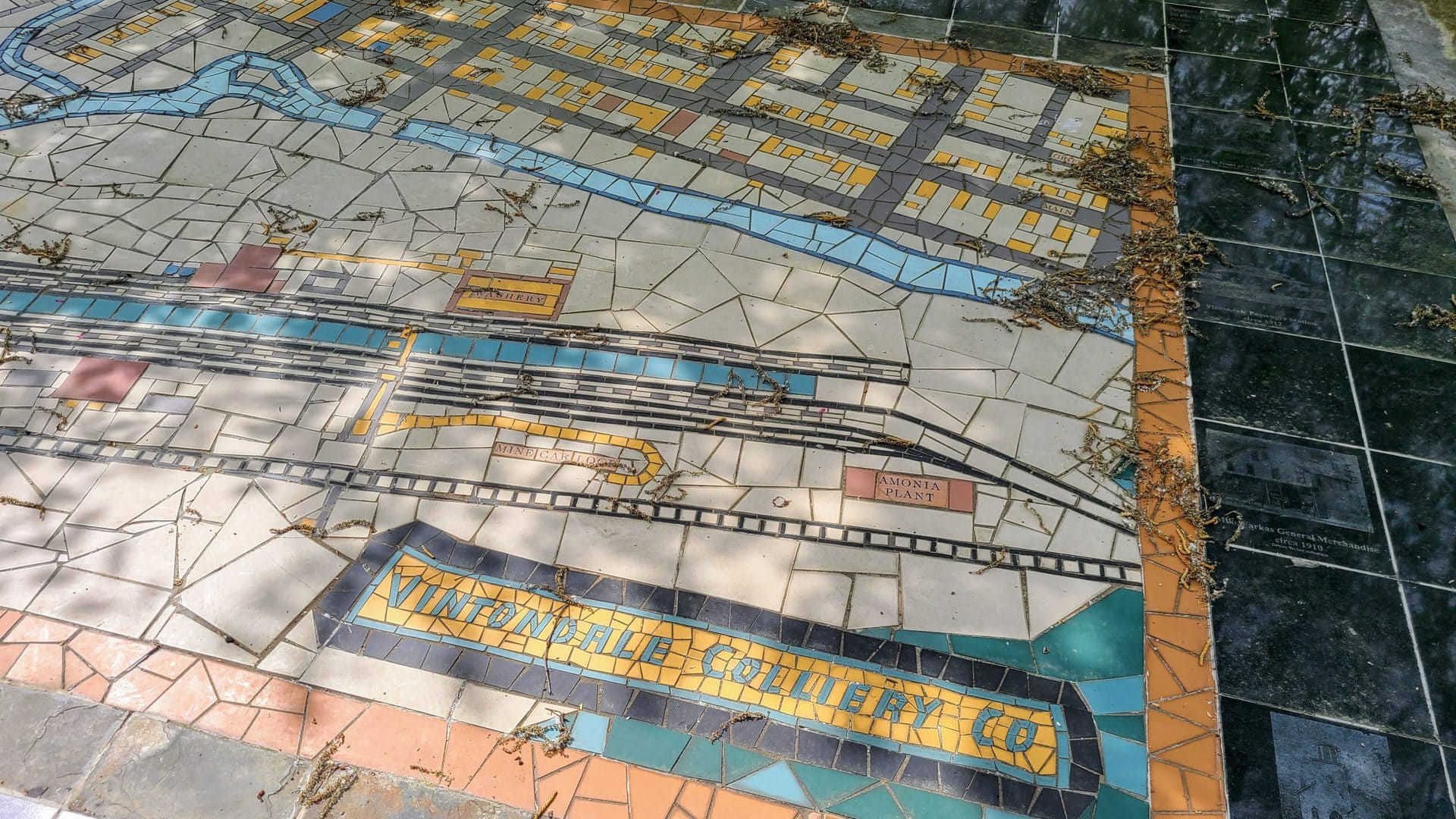
Directly across the trail is a tile mosaic of Vintondale reflecting a 1923 Sanborn Insurance map of the town. These maps were produced from 1867 to 1977 and were used to help insurance adjusters calculate risk. Today they’re useful as a way to see how a town or region has changed over time.
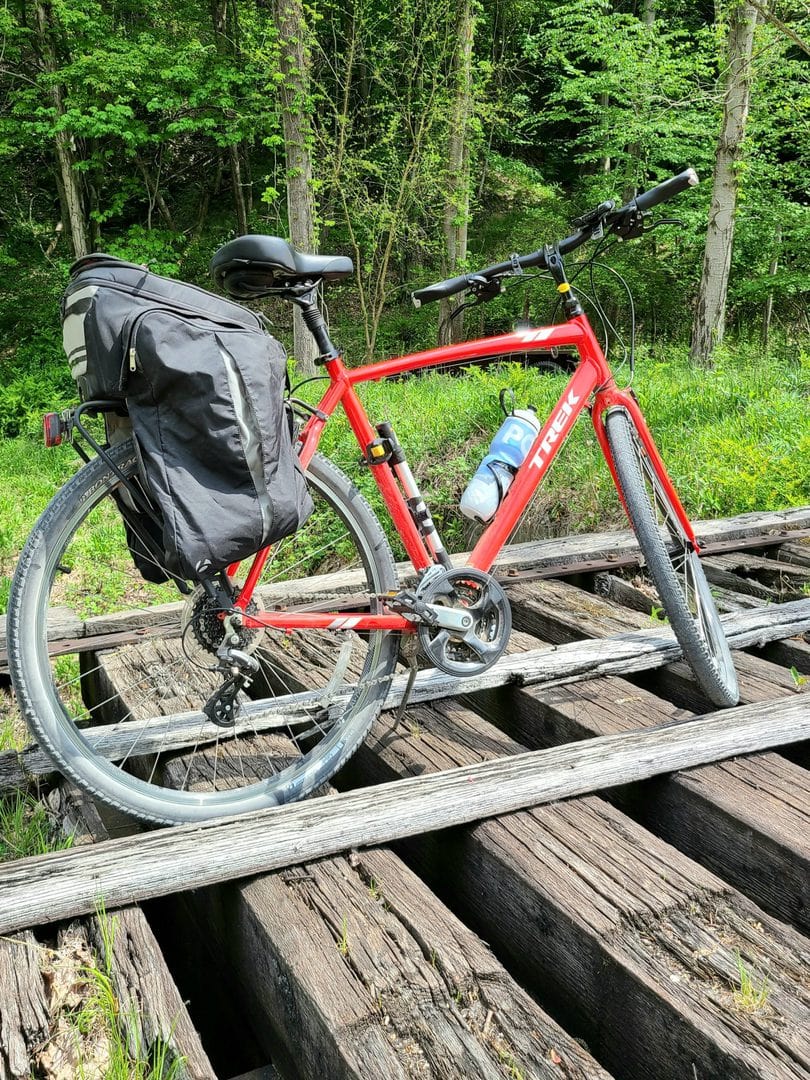
There were some railroad ties running over where the coal cars would have come out of the mine. I couldn’t NOT take a picture of my bike — a 2017 Trek Verve 2 with a SQlab 621 active saddle and Bontrager Interchange pannier. Red, because my wife liked the color.
Vintondale is almost entirely residential. Don’t expect to find any convenience stores or places to resupply. There’s a surprisingly clean and well-maintained public restroom along the trail, however.
Immediately outside the town is the Eliza furnace. Built in 1846, the furnace went bankrupt in 1849 thanks to the low quality of local iron ore, the high shipping costs to Johnstown, and the fact that its technology was already outdated when it was built. What makes this furnace special is the fact that it’s one of the few furnaces with a heat exchanger still attached on top. This was designed to boost the combustion temperature by capturing waste heat from the exhaust, but it didn’t make any significant difference.
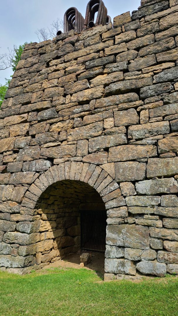
The furnace is easily accessible from the trail. For obvious reasons the entry points are fenced off.
As I headed west out of Vintondale, I came across the northern spur of the trail. Eventually the spur will make a complete loop back to Nanty Glo. For today, I chose to continue westward to Black Lick.
Not even a mile past Vintondale I came across the remains of Wehrum. Built as a company town in 1901, the coal company unexpectedly and abruptly closed up shop in 1929 after a series of explosions and other safety problems. As was the norm for coal towns, the families were unceremoniously evicted and the homes and buildings were torn down for scrap.
In 2020, 25000 tons of material was removed from the site. Some of the material was used to backfill dangerous hazards including cleaning pits and a 160-foot deep mine shaft. Nearly a century after it closed up for good, the town of Wehrum has been, put simply, deleted

About seven miles later I came across the Dillweed B&B and cafe. There’s nothing fancy here, but they have an assortment of sandwiches, beverages, and frozen treats. A large pavilion across the street provides ample covered room and seating, even for large groups. By this point I had already blown almost my entire allotted time on the trail from stopping to explore, and I still wasn’t even two thirds of the way home!
This is the only place to resupply between Nanty Glo and Black Lick.

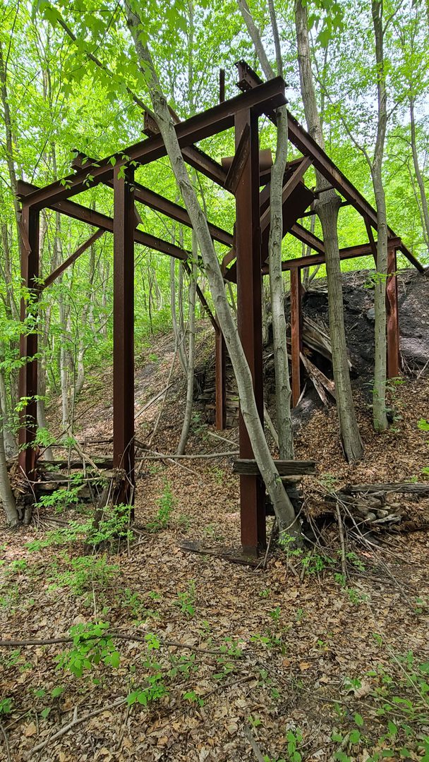
Further up the trail I encountered an old, long-forgotten coal tipple. Or at least what’s left of it. As recently as the 1960s there were several active coal mines in the vicinity. The Vinton No 17 was almost directly across the creek and No 16 would’ve had a portal near the tipple. Assuming the ages line up, this would’ve been part of their workings. A mine map from 1967 identifies this as the “Dias tipple”. There aren’t any workings with that name but that same map indicates several tracts of nearby land owned by George M Dias, S A Dias, and E E Dias.
Just past the tipple I came across the worst example of AMD on the entire trail. Since coal mines typically run well below the local water table, massive pumps are required to drain all the water out. But once the mine is abandoned, those pumps are shut off and the mine fills with water. That water leeches out minerals like iron, manganese, and aluminum, and eventually escapes into the wild. Thanks to its rich coal mining heritage, Pennsylvania is riddled with AMD. Unfortunately many of the mining companies went bankrupt over half a century ago and taxpayers are left to clean up the mess.
Bright orange water is the giveaway. This is coming out of the abandoned Vinton No 16 mine and drains directly into Blacklick creek, poisoning the waterway.

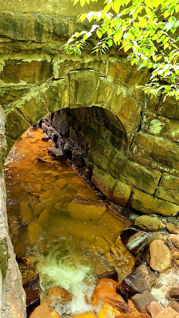
Note the chalky white water flowing through the rocks on the left hand side. This may contain dissolved limestone, which ironically is used as one step in the treatment of AMD. This could indicate a malfunctioning passive AMD treatment plant nearby, or possibly a limestone deposit.
Here’s another shot of the same unnamed creek flowing beneath the railbed.
Continuing westbound I ran into the Buena Vista furnace. I almost skipped it because by now I had already spent three hours on the trail taking photos and exploring, but I’m glad I took the short detour. This big guy was built in 1847 and ran through 1856 — despite nearly going bankrupt in 1850. The workers here worked long, dangerous shifts. Imagine dumping wheelbarrows full of limestone, charcoal, and pig iron into the top of this thing while it was churning away at full power.
Unfortunately parts of the furnace are crumbling down, and it looks like it’s just a few heavy snowfalls or torrential downpours away from being turned into a pile of rocks. I chose to capture it from its good side.

By this point I was about seven miles from the end of the trail. My wife was going to meet me in Black Lick to drive us back to the hotel, so I Signal’d her the 30-minute warning. Immediately after deciding that I wasn’t going to stop and do any more exploring I came across this glorious thing:

Behold the bridge to Claghorn!
Claghorn was another coal mining town that simply packed up and vanished. In an act of foreshadowing, the town was named after a mine superintendent (Clarence Claghorn) from the nearby town of Wehrum. Construction started in 1903 and was almost immediately abandoned due to an economic downturn. Another mining company purchased it in 1916 and finished it out for use by miners at the Vinton collieries. The bridge was built in 1917 for a sum of $19,000.
Less then ten years later, the mines this town was built for unceremoniously shut down. The coal quality was poor and the working conditions were terrible. They were called “low mines” because the miners often only had three to five feet of headroom to work in. A reclamation map from the early 90s shows the Vinton No 17 as the closest mine, but it’s likely that the small mines worked by this town were stripped out long ago.
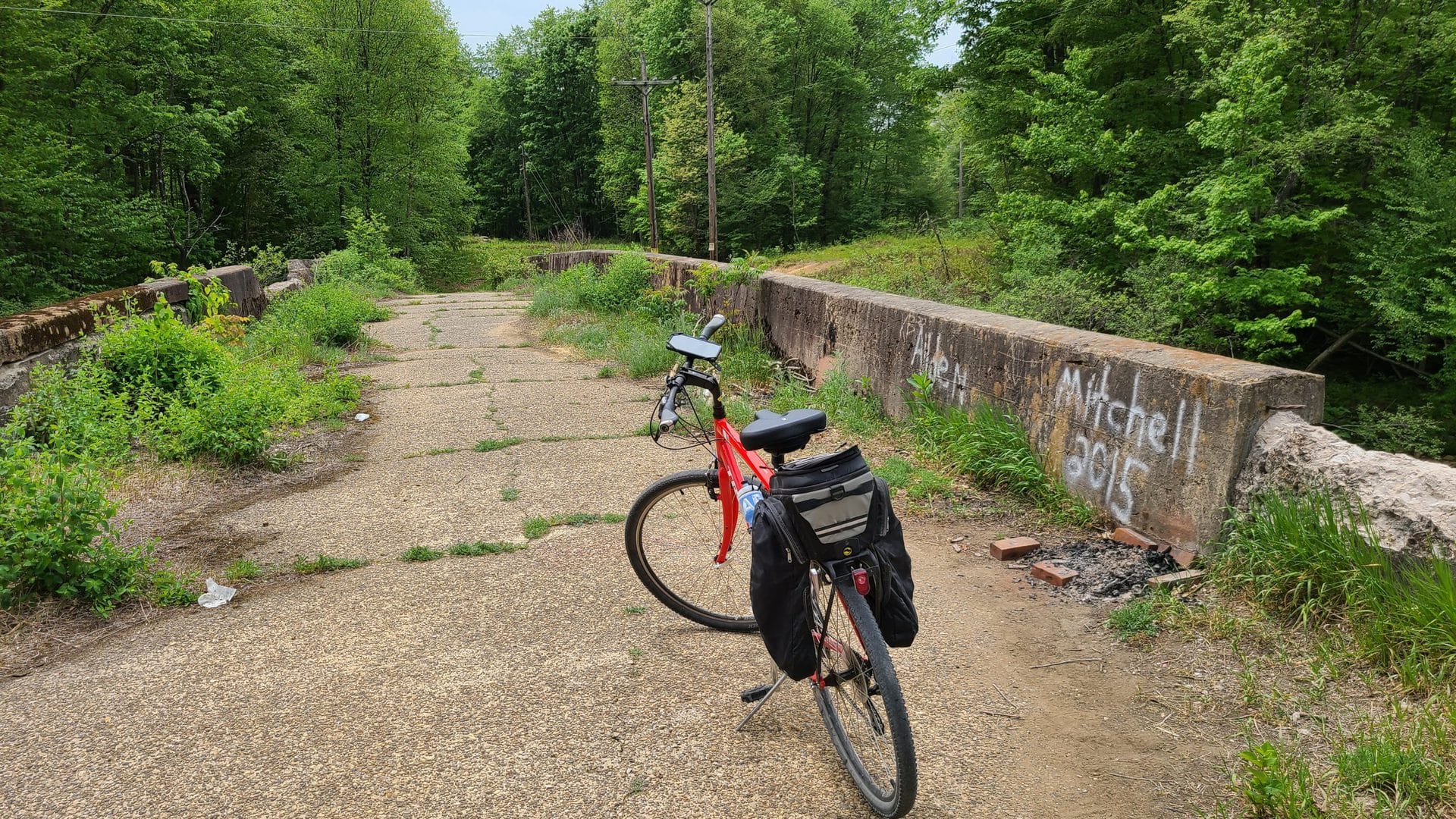
Looking across the bridge, Claghorn’s main street would have veered through the clearing on the right. Some foundations are visible from aerial photos. Unfortunately as soon as you reach the end of the bridge you’re greeted with “NO TRESPASSING” signs. All the land is now privately owned.
Look at this bridge though. By Pennsylvania standards, this bridge would be deemed “adequate” and kept in service for at least another 50 years.
Five miles from the western terminus, a mural awaits. Just up the hill and to the right of this mural sits another coal tipple. This one was abandoned after the Johnstown Flood of 1977. The water rose high enough that a fully-loaded train was stranded here on the tracks. Walk over to the creek bank, look down, and just think about how much water it would have taken to raise the creek that much.

According to a nearby plaque, the railroad tracks were torn up in 1998 and construction of this segment of the trail began in 2005.
By now my ride was already waiting and I had another five miles — about 20 minutes — to go. Naturally, this was the point where I realized I didn’t bring enough water. I decided to just power through the last five miles, because what else could there be to see?
Everything. That’s the answer. As I was trying to make up time, countless abandoned buildings, discarded rail cars, and rotting industrial machinery were calling to me from along the trail. This fall I’m going to tackle the trail heading east from Black Lick so I can block off enough time to see what I missed.