The West Penn Trail is what you get when you cross a well-maintained, paved, road-bike friendly trail with a well-maintained, single-track, goat-friendly mountain bike trail. After just a single ride, I’m making this one of my favorite trails of all time.
The West Penn Trail has so much to offer that I had to split this update into multiple posts. Even if you strip away its history, it’s like riding four trails in one:
- Five miles of shady, flat, well-maintained trail along the river near Saltsburg PA. This is easily accessible to road bikes and new riders.
- Three miles of hilly, single-track riding through state game lands. This segment is pushing it for a road bike.
- One mile of hilly switchbacks climbing over Bow Ridge. You’ll want a hybrid, gravel, or mountain bike to traverse this section.
- About 4.5 miles of flat trails crossing five bridges heading towards Blairsville PA.
Future plans call for the trail to be extended north to Apollo and east to the Hoodlebug and Ghost Town Trails. Whatever you can say about Western Pennsylvania’s industrial heritage, they’re committed to making the most of it with their trail network. Central and eastern PA could learn a thing or two.
The trail dates back nearly 200 years to the Pennsylvania Canal. Originally built in the 1820s, the canal gave way to the railroads in 1857. The main line is still partially used by rail traffic today, which means the West Penn Trail takes a hilly diversion through state game lands west of the Conemaugh Dam. There is so much history along the trail that I had to stop looking at artifacts in order to actually, you know, ride the trail.
I started my adventure in Saltsburg, which conveniently anchors both the West Penn and Westmoreland Heritage Trail. This small town has several taverns, restaurants, and public bathrooms within a block or two of the trail, along with plenty of parking at the trailhead. The trails are well-marked and very easy to pick up from here. If you’re a first-time rider, or if you’re riding with young children, you’d be hard pressed to find a better place to start your adventure!

Heading east, the trail begins with about 4-5 miles of mostly shaded, mostly flat, well-maintained trail. This segment is very gentle and suitable for all bikes and riding levels. This is the old rail grade and it shows. The trail runs past numerous coke ovens, coal mines, and bridges, giving a glimpse into the past two centuries of industrial heritage.

About 4.5 miles east of Saltsburg, the trail diverts from the railbed and cuts through Stage Game Lands 328. If you’re riding this during hunting season, make sure you’re wearing your safety orange.
This segment is called the Dick Mayer section, and it’s a markedly different trail from the previous section. The first quarter mile is pretty forgiving, but after Elders Run Tunnel you’ll encounter rougher terrain and significant hills. You might be able to coax a road bike up to the tunnel, but I wouldn’t try going east with anything lighter than a hybrid or gravel bike.

I can find very little information about Elders Run tunnel. From what I can put together, it was built when the railroad was realigned in the 1950s. It’s more of a bridge than a tunnel; it doesn’t appear that rail or vehicular traffic ever ran underneath. Fortunately, there’s a very wide path leading the trail through.


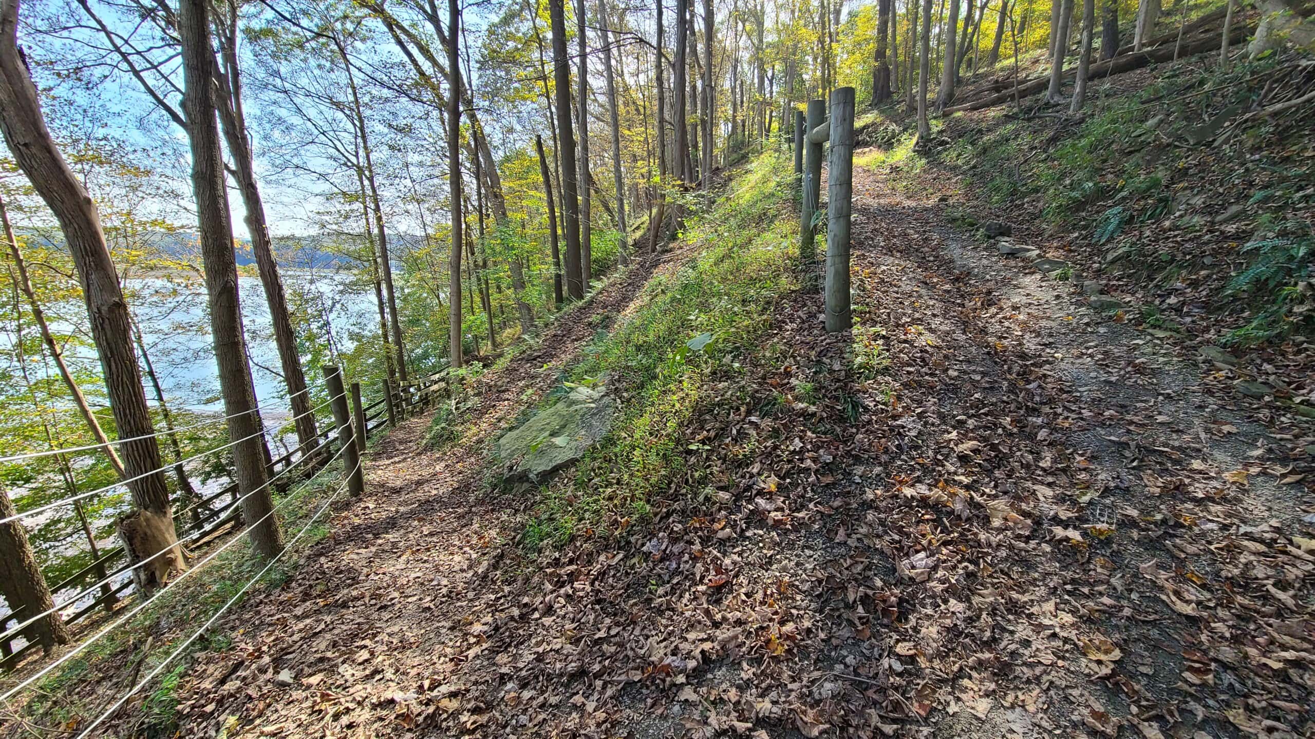
Immediately after the tunnel, you’ll see what you came for. The eastbound trail begins a 1.5-mile ascent of about 3% – 6%. I won’t lie — I had to stop and hoof it at least once. I’ve ridden steeper grades but after riding the Greene River Trail the day before and not sleeping well overnight, I think my endurance just wasn’t awake yet.
The Dick Mayer segment is like an extremely gentle mountain bike trail. That initial climb is the worst (though there’s another just like it a mile ahead), so if you can pull that off, you’ll be fine for the entire journey to the Conemaugh Dam. The beauty through the woods can’t be overstated; this is an incredible trail.
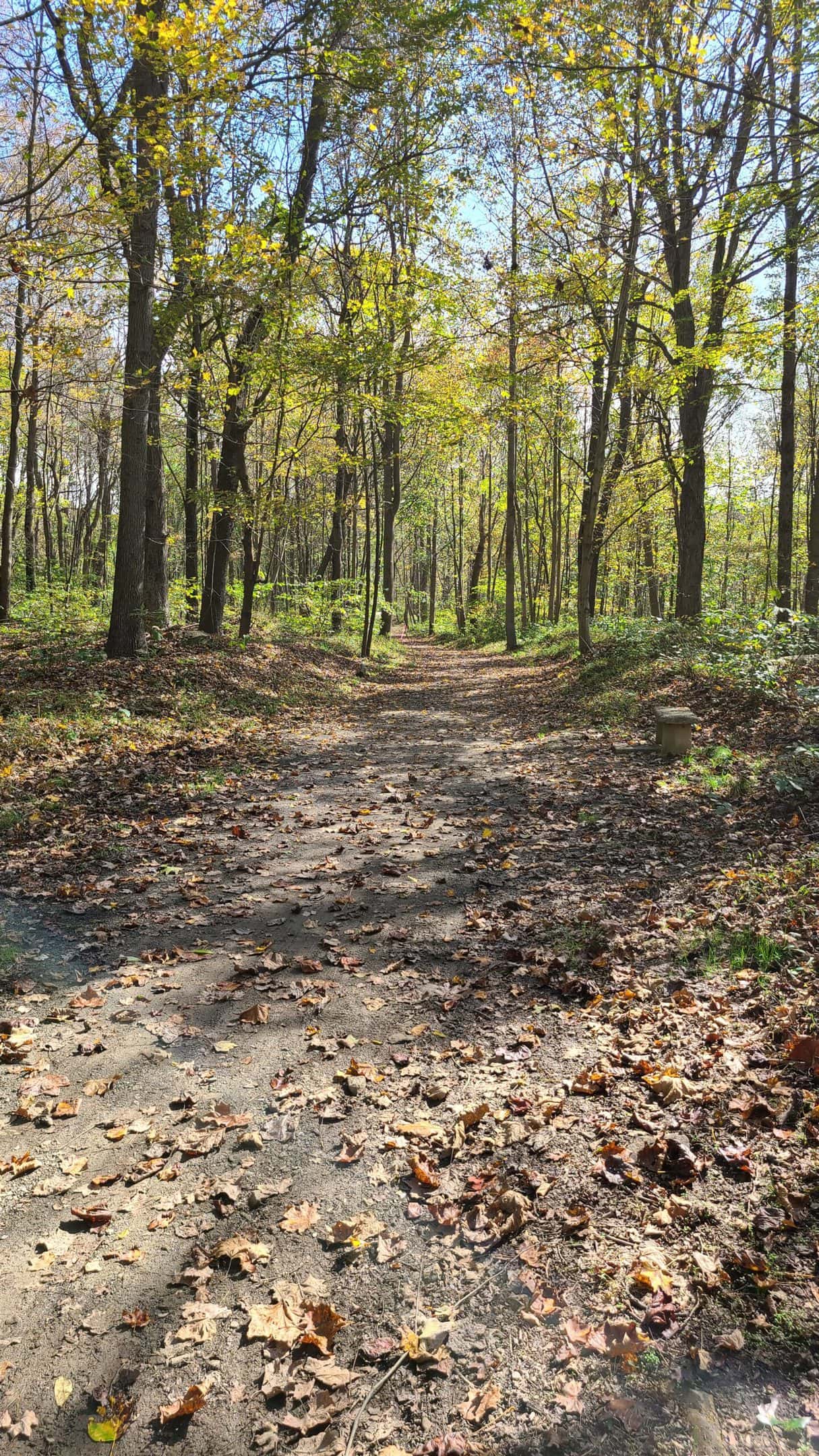


Take a close look at the third photo above. Can you see the trail? The final half mile between Auen Road and the Conemaugh Dam can be a little hard to follow, especially in the fall.
Keep pedaling on, and eventually you’ll arrive at the Conemaugh Dam. Built in 1952, the dam was the state’s response to repeated flooding along the Conemaugh River — including a 1936 flood that became known as the worst flood in Pittsburgh history. Since being built, it has saved nearby communities from more than $2.2 billion in flood damage.
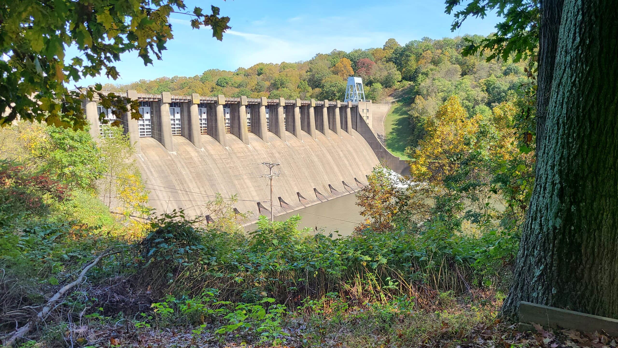
The dam anchors a national recreation area, and is surrounded by a small park including plenty of parking, multiple restrooms, and several wildlife observation areas. The dam marks roughly the halfway mark, so if you want to break up your ride with a picnic, there’s no shortage of tables, benches, and open space.
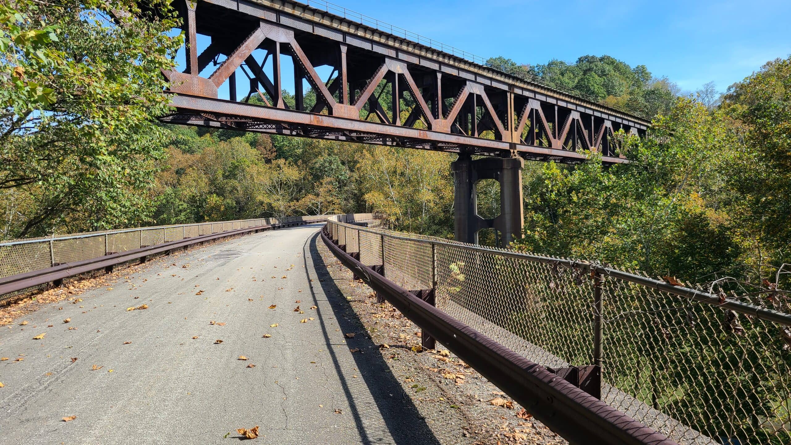
My favorite part of the trail begins immediately after the dam in the Tunnelview historic site. I can’t possibly cover the history of Tunnelview in a single post. Long story short, it was the site of some incredible engineering for the canal and railroads that passed through here — including an aqueduct that carried the canal over the river.
The bridge I’m standing on in the photo above carried traffic from the tunnel below to points west. It was built in 1907 and withstood the 1936 St. Patrick’s Day flood. The railroad abandoned it when it re-routed the track in 1952. The trail takes you over this older bridge to the site of the first of four tunnels slicing through Bow Ridge.

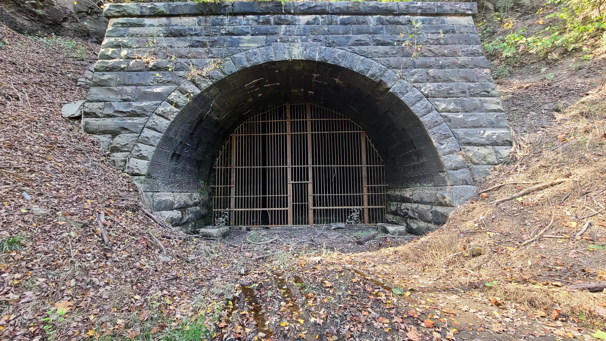
The first tunnel I came to was built in 1907. It was was bypassed in the 1950s (see the upper bridge in the photo above) when the Conemaugh Dam was built. Because the dam raised the water level on the other side, this tunnel was sealed with a two-foot-thick concrete “plug” to prevent it from emptying the reservoir during floods.
The inscription on the arch reads “A.C. Shand, Chief Engineer. McMenamin & Sims, Contractors – 1907”.

Barely a tenth of a mile up the trail sits the next oldest tunnel. This was built in the late 1850s and early 1860s. It was originally built as part of the North Western Railroad, whose goal was to transport freight directly from Philadelphia to Chicago — bypassing Pittsburgh entirely. The North Western went under in 1858, and this tunnel was opened as part of the West Penn Railroad in 1864. Like the 1907 tunnel, this tunnel is plugged to prevent the reservoir from draining.
Piers from a bridge used in the 1864 alignment are still easily visible. It’s likely that stones used for the tunnel, bridge, or both came from the Pennsylvania Canal.

A third tunnel sits almost exactly halfway between these two tunnels. It was built in 1830 to allow the Pennsylvania Canal to cut through Bow Ridge. This was only the third public tunnel built in the United States, and the Pennsylvania Canal Commissioners had to explain it to the public as “like a large well, dug horizontally through a mountain“.
This tunnel was paired with a stone aqueduct to carry the canal over the river safely. Few traces of either remain today, but a drainage pipe can be seen leading water out of whatever is left inside. The eastern portal sits well below the waterline upstream of the dam. There is exactly one surviving photo of the aqueduct.
The fourth tunnel was built in 1989 to serve as an intake for a small hydroelectric dam just downstream of the Conemaugh Dam. There isn’t much to see here and for obvious reasons, the tunnel isn’t accessible.


To get to the other side of the tunnels, the trail climbs over Bow Ridge. This is by far the most difficult section of the trail. Once you cross the 1907 bridge it’s about one mile to the corresponding bridge on the other side. In that time you’ll go up, and then down, about 150 feet over several switchbacks.
That may not sound like much but it results in much of the segment being about 5% – 7%. The eastern side has the worst of it and maxes out at about an 18% grade. It’s so steep it actually has two sets of stairs for your bike.
Seriously — stairs.
The ramp on the side of the stairs allows you to wheel your bike up and down safely. No matter how hard or light I worked the brakes, my bike decided it was either going to freewheel or bounce down the ramp. There’s no easy path here; be prepared to wrangle your bike.
There are multiple signs along this segment warning you to stop riding already and walk your bike. Heed them.
Once you get to the other side of Bow Ridge, the trail changes considerably once again. You’re now past the hard part and you’ve got a gentle, mostly flat five mile ride east towards Blairsville. But before you take off, stop to look around.
You’re now at the eastern portal of the 1907 tunnel. Debris near the entrance marks the last time water rose to this level.
If you look around, you can also see the remains of the eastern portal of the 1864 tunnel. It has clearly seen better days. I’m unclear on whether this is part of the plug or due to a collapse, but what you see here is all that remains. Note the detail on the stones lining what would’ve been the tunnel. Given the position of those stones I suspect this occurred within the last few years.

From here, the trail continues about five miles east towards the town of Blairsville PA. It departs the tunnels by way of this old rail bridge that follows the 1907 alignment. This bridge gets completely submerged several times a year, which is a testament to two things:
- The engineers and laborers who built this bridge were astounding. Imagine if a typical Interstate bridge got submerged several times each year — how long until it fell in on itself? This bridge is over a century old, and it’s been getting completely submerged for the past 70 years.
- You need to make sure the water levels don’t exceed 910 feet before you go.

My next post on this trail will cover the segment between Bow Ridge and Blairsville, and hopefully some of the historic aspects I had to skip over on my first trip. If you decide to check out the trail before then, remember that parts of it run through state game lands — be sure to wear orange!